


Massif du Sud regional park offers a singletrack mountain biking trails network adding to the gravel bike network (wide and graveled roads). The actual network offers around 17 kilometers of singletrack trails and 30 kilometers of gravel bike trails.
Mountain bike trails
Singletrack
The singletrack trails at Massif du Sud regional park are accessible, as most trails are suited for families and riders of all levels going at their own pace. There are few obstacles on the trails and there is almost always an easy bypass for the less experienced cyclists.
SAGETY GUIDELINES AND USEFUL TIPS FOR MOUNTAIN BIKING
BEFORE YOU LEAVE
- Choose synthetic clothing rather than cotton, they will dry faster and keep you warm even if they are wet
- Bring enough water (1 litre minimum) and a snack
- Do an overall check-up of your bike, paying closer attention to your brakes
- Bring a small backpack with a headlamp, matches, sunscreen lotion, a first aid kit and a trail map
- Plan your itinerary on a map and let someone know of your plan, including departure and return time
- Choose a trail that fits your capacities (average speed of 5 km/h) taking into account the sunshine duration
- Warm-up and stretch to reduce risks of injuries
- Check the weather forecast before leaving
WHILE BIKING
- For your own safety, never leave alone
- Always wear a helmet
- Always stay on the trail and pay attention to the signs
- Control your speed at all times and never stop in the middle or at the bottom of a hill
- Keep a reasonable distance from the cyclists in front and behind you
- Drink water often and in small quantities
- Carry your trash with you to dispose of it in a garbage bin
- Don’t hesitate to evaluate your itinerary during the day and to turn around if necessary
What to do if you are injured and cannot move?
- First, if you have a cellphone with you, see if you have cellphone signal where you are. If so, call the visitor center at 418-469-2228 extension 101. Explain your situation and ask for help.
- If you don’t have cellphone signal where you are, but you’re not alone, protect yourself from the cold, the wind and the ground. Once you are in a stable position, ask your partner to go get help at the visitor center.
- If you are by yourself, cannot move and don’t have cellphone signal, try to stay as warm as possible and protect yourself from the ground with some form of insulation. Stay close to the trail and try to be easy to see by other users or the rescue team.
In any case, never leave the signaled areas.
What to do if you are lost?
- If you left the signaled area and you don’t know where you are, turn back following your tracks until you reach the signaled area.
- If you cannot see your tracks, and are on a slope, slowly make you way down: most of our trails follow rivers or streams in the valleys. If you reach a river or a stream, follow it until you reach a trail.
- If you cannot see your tracks, and even by going down into the valley you cannot find any stream, river or trail, but you have a cellphone, see if you have cellphone signal where you are. If so, call the visitor center at 418-469-2228 extension 101. Explain your situation and ask for help.
- If you don’t have cellphone signal where you are, you cannot see your tracks and are lost outside of the signaled area, try to orientate yourself: try to find a summit or another clue to where you might be. Move only if you are sure of the direction you’re heading to.
- Otherwise, the best thing to do is to stay where you are, to protect yourself as much as possible from the elements, to make sure you are easy to see using any colorful object (clothing, tent, tarp, etc.) and, if you have one, by using your whistle, or calling for help. If night falls, turn a headlamp on or start a fire to ensure you are easy to spot.
In any case, it is preferable to wait for help rather than spending your energy going around in circles in the woods.
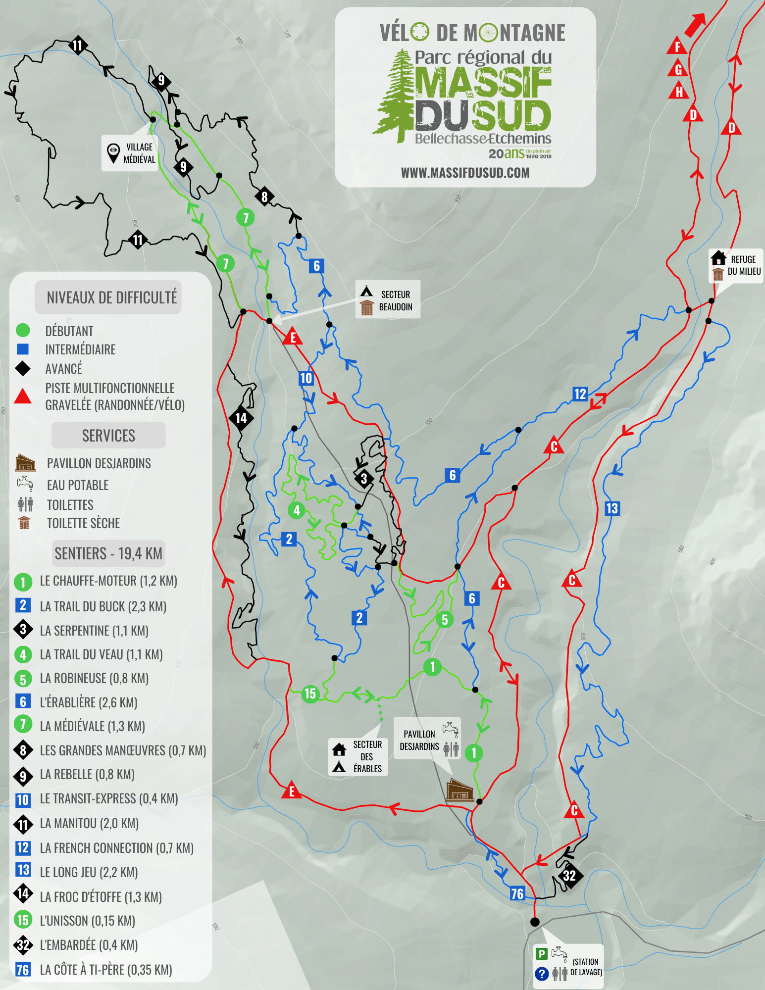
Trail map |
See trail map |
You can also use our geolocated map on ONDAGO.

Le Chauffe-moteur – Level: easy – Length: 1.2 km – Elevation gain: + 49 m, – 2 m

The name: Engine block heater – Going uphill on all its length, this trail allows the biker to warm up (if not heat up!) before moving on to other trails.
Wide and gravelled, le Chauffe-moteur has very few obstacles. This two-way trail can easily be ridden by beginners and willing kids. Be careful with the oncoming riders. The trail gives access to the Trail du Buck and the Érablière.
La Trail du Buck – Level: moderate – Length: 2.3 km – Elevation gain: + 73 m, – 73 m

The name: Buck’s trail – While our team worked on the trail, they saw their work almost daily trampled on by moose, called “buck” by hunters.
The first part of the trail gradually climbs, overlooking the river, and has you cross some boardwalks. The descent then starts gently, with several berms and a few rocky sections. The trail brings you either to the Serpentine, the Trail du Veau, or back to the Chauffe-moteur and the visitor center.
La Serpentine – Level: difficult– Length: 1.1 km – Elevation gain: + 43 m, – 37 m

The name: Serpentine – The trail offers lots of switchbacks, bringing to mind the movement of the snake (serpent) but it’s also a reminder of one of the park’s mineral beauty, the serpentine stone.
Right from the start, you can feel this trail is going to be of another level of difficulty. A small jump built with rocks and a quite technical pass (tight turns, wooden bridge, rocks) set the tone. The trail then offers two consecutive rock drops before going up a long series of switchbacks with tight, narrow turns, reminding you that not only descents can be technical! The trail brings you halfway through the Trail du Buck.
La Trail du Veau – Level: easy – Length: 1.1 km – Elevation gain: + 28 m, – 29 m

The name: – Moose calf’s trail – Just like the Trail du Buck, this trail is frequently visited by moose, which, like us, find it easier to travel on a trail than in the bush. Shorter and easier than the Trail du Buck, it deserved the baby’s name!
Perfect for beginners or families wanting to initiate their kids, the trail is relatively flat and has next to no obstacles along the way, allowing you to become confortable on your bike. On the second part of the trail, you will find berms an very gentle descents. The trail ends in the Trail du Buck and can lead to the Serpentine (shortcut).
La Robineuse – Level: easy – Length: 0.8 km – Elevation gain: + 10 m, – 34 m

The name – Drunkard – While the Robineuse trail was being built, a considerable amount of empty beer cans and bottles were found along the way. Was it a secret party area? A bootleg trail? Who knows!
With its negative elevation gain, the Robineuse is all about rolling downhill! The trail begins with a gradual descent with many berms and several small and easy gravel jumps. Turns can be sharp, but it’s generally pretty safe to gain significant speed on this trail. The trail ends at a fork with the Érablière.
L’Érablière – Level: moderate– Length: 2.6 km – Elevation gain: + 140 m, – 72 m

The name – Maple forest – Entirely located in a pure maple forest, we may have been tired of trying to find new and orginal names for our trails… So, there it is for this sweet ride!
L’Erabliere climbs very gently at first, then more steadily with several switchbacks after it crosses a service gravel road. Since, as they say, everything going up must at some point go down, at about two thirds of the way, L’erabliere starts its descent, quite abruptly, with berm turns to help you keep a decent speed while going down. The trail meets the Grandes Manoeuvres before the descent and ends at the Médiévale at the bottom of it.
La Médiévale – Level: easy – Length: 1.3 km – Elevation gain: + 34 m, – 41 m

The name – Medieval– Set around the ruins of a medieval village, the trail gives you a glimpse of what life was like back…when people built and used it for live action role playing games.
La Medievale is a wide, gravelled two-way trail. It is a relatively easy trail apart from the first long uphill section leading to the medieval village. One must be careful in this specific section, as riders tend to gain considerable speed going downhill. The trail leads to the Rebelle and the Manitou.
Les Grandes manœuvres – Level: difficult – Length: 0.7 km – Elevation gain: + 43 m, – 50 m

The name : The Grand Maneuvers – The trail was baptised that way because of the long downhill section with huge berms at the end of the trail, requiring some skill and dexterity from the rider.
Les Grandes Manoeuvres is rated difficult , but it is not as technically difficult as, let’s say, the Rebelle. The rating is mainly due to the looooong downhill that ends the trail. Beginners with a little riding experience should nevertheless be able to ride this trail without problems, going at a slower speed in the downhill section. The trail gives access to the Médiévale and the Rebelle.
La Rebelle – Level: difficult – Length: 0.8 km – Elevation gain: + 21 m, – 28 m

The name : Rebel – There is no consensus among employees of the park on where the name comes from. Some say it is because it is the most difficult and technical trail of the park, others claim it is related to the rebellious attitude of the designer of this particular trail. Anyways…we like the name so it is probably there to stay!
The most technical trail of the park begins with a short, steep climb, followed by a steep, dowhnhill rocky section leading to the shore of the river. Then comes a flowy section along the river with some jumps and berms (don’t go too fast or you might miss the pretty river basin, a nice place for a quick dip in the water…). It keeps going with a series of quick turns, descents and small jumps. But since all good things have an end, it eventually reaches La Médiévale (7), where it ends.
Le Transit-Express – Level: moderate – Length: 0.4 km – Elevation gain: + 3 m, – 34 m
The name: This trail was created to link the Erablière and the Trail du Buck. Hence the name: Le Transit-Express.
Short and intense, this downhill trail offers several options (rock stairs, skinny, etc.) to suit any level of rider – from beginner to expert. It connects L’Érablière to La Trail du Buck. Be careful: this trail crosses a gravel road with car traffic.
La Manitou – Level: difficult – Length: 2 km – Elevation gain: + 88 m, – 110 m

The name: Handle everything – With a bit of everything: uphill, downhill, and technical sections, berm turns and jumps, this trail calls for a well-rounded rider. Although not very catchy in English, the French name Manitou (manie-tout) literally translates to ”handle everything”. Genius, right?
Starting next to the medieval village, with a short, technical section built manually, the trail then crosses the river and begins a long gradual ascent, followed by a series of downhill berms all the way to the Grand Finale, a very wide berm turn. From there, you can reach the visitor center by the E trail.
La French Connection – Level: moderate – Length: 0.7 km – Elevation gain: + 21 m, – 14 m

The name : No translation needed for this one! Built to connect two trails, it could have been called ”The (formerly) Missing Link” or ”The Umbilical Cord”…but we finally opted for ”La French Connection”, to keep it a bit French!
The trail begins by a short descent across a river, followed by a short but steep climb. The remainder of the trail follows the limits of the ecological reserve, on a plateau, in a coniferous forest. The French Connection ends at the C and D trail fork, near the Refuge du Milieu, and leads to the Long jeu.
Le Long Jeu – Level: moderate – Length: 2.2 km – Elevation gain: + 56 m, – 117 m

The name : Long play (LP) – Just like the LP allowed to listen to longer albums on the record player (wikipedia told us!), the Long jeu makes the pleasure of riding your bike last a little bit longer!
A gradual descent brings you backs towards the visitor center. Punctuated by some nice turns and small jumps, this trail is nothing too difficult. The perfect way to end a day of riding!
La Froc d'étoffe – Level: difficult – Length: 1.3 km – Elevation gain: + 50 m, – 105 m
")
The name: The Froc d´étoffe is the brainchild of Eric Laflamme and Steve Fontaine, designers of the trail, and the work of our team of volunteers, the Frocs d´étoffe. The bridges are the work of Jean-Pierre Tremblay and Martin Cayouette. Behind the wheel of his mechanical shovel, artist Donald Létourneau went to great lengths to preserve the natural aspect of the trail.
La Froc d’étoffe has the temper of a signature trail. Nestled between the E trail and the Beaudoin stream, it offers a magnificent view of the water. Hang on to your handlebars, the Froc d’étoffe is not for beginners! The “old school” type trail presents the two most vertiginous descents in the park, both crowned by a berm a stone’s throw from the stream. Several sharp turns, jumps and short steep climbs call on the technical skills of cyclists. Mountain biking as it did not exist before in the Massif du Sud regional park!
L'Unisson – Level: easy– Length: 0.1 km – Elevation gain: + 11 m
")
The name: The name was suggested by Steve Turgeon, a volunteer at the park, and underlines the union between two types of trail, one more polished and therefore more accessible, the other more “old school” and more rugged. This trail was built by our team of volunteers, the “Frocs d’étoffe”.
L’Unisson is a short trail that brings together the Froc d’étoffe (14) and the Chauffe-moteur (1), thus the new network and the old one. At the end of L’Unisson, cyclists can continue the descent to the park entrance (1.1 km) or choose to stay in the saddle and join the Trail du Buck (2).
L'Embardée – Level: difficult– Length: 0.4 km – Elevation gain: - 34 m
")
The name: This trail was named in honor of a friend and colleague, Marc-André, nicknamed “32” (who knows why!). During the work leading up to the park’s new trails, Marc-André swerved behind the wheel of a golf cart and found himself balanced on a stump. We are still talking about it! This trail was built by our team of volunteers, the “Frocs d’étoffe”.
L’Embardée is the logical continuation of the Long jeu (13), but the “old school” version. This trail adds to a descent that has already lasted 2 km and puts the finishing touch to a great day of cycling. The trail presents a particularly exhilarating short descent, straddling a ridge, which ends in a berm. The arrival is very close to the Milieu stream. All that remains is to walk the few meters that separate the parking lot, put your bike away and enjoy a well-deserved moment of rest.
La côte à Ti-Père – Level: moderate – Length: 0.4 km – Elevation gain: + 33 m
")
The name: This trail was named in honor of Claude Gignac, regular visitor to the park, volunteer and colleague. It was also from him that the idea of the Trail du Massif du Sud came about. It is proof that age does not matter when we are passionate about the outdoors.
La côte à Ti-Père begins at the entrance to the park and allows cyclists to ride in peace, without having to deal with cars. The climb first makes a few switchbacks before crossing a gravel road then a bridge, and finally emerge at the Desjardins pavilion. Next step: The Chauffe-moteur (1).
Gravel bike network
Massif du Sud regional park also offers, for gravel, hybrid and mountain bikes, 30 kilometers of gravel bike trails, of which 13 are located in the mountain summit area. These roads, called ”pistes”, have a multifunctional use, as they also serve as hiking trails during summer and for cross-country skiing during winter.
We do not recommend using these roads with road tires; however they are suitable for gravel bikes, bike trailers and strollers.
Bienvenue cyclistes
Massif du Sud regional park is now part of the Bienvenue cyclistes! movement. We offer a camping space, even without a reservation, if you are travelling exclusively by bicycle and also access to basic tools for minor repairs. More information on Bienvenue cyclistes!
