


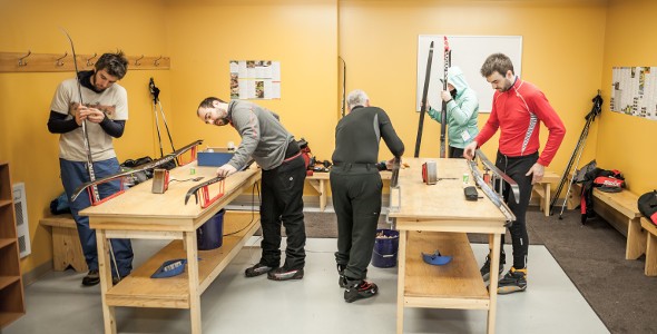
A vast network
A real paradise for cross-country skiers, the network* at Massif du Sud regional park is groomed regularly during the week and every day on weekends and a few heated mountain huts are available for a well-deserved stop.
In the tranquility of the ancient forest, amidst landscapes as exceptional as the Ghost Valley of the Monts-Valin, combine physical activities with mental healing as you contemplate the beauties of nature.
*The trails are designed for classic cross-country skiing and are not suitable for free technique (no skating). It is not allowed to ski with a dog for safety reasons. The multifunctional trails used for cross-country skiing are not very wide and accommodate fat bikes as well.
Tracing tracks days
Beginning February 6, 2023, here is the schedule of our team responsible to trace our cross-country tracks :
From Monday to Thursday included
tracks B-C-D-F only will be traced
From Friday to Sunday included
all our tracks B-B1-C-D-E-F-G and H will be traced
SAFETY GUIDELINES AND USEFUL TIPS FOR CROSS-COUNTRY SKIING
BEFORE YOU LEAVE
- Choose synthetic clothing rather than cotton, they will dry faster and keep you warm even if they are wet
- Bring spare clothing, such as socks, mitts and hats
- Bring enough water (1 litre minimum) and a snack
- Bring a small backpack with a headlamp, matches, sunscreen lotion, a first aid kit and a trail map
- Plan your itinerary on a map and let someone know of your plan, including departure and return time
- Choose a trail that fits your capacities (average speed of 5 km/h) taking into account the reduced sunshine duration during winter
- Warm-up and stretch to reduce risks of injuries
- Check the weather forecast before leaving
WHILE SKIING
- For your own safety, never leave alone
- Always stay on the trail and pay attention to the signs
- Don’t wear the straps of your poles around your wrists. That way, if you fall or your poles gets stuck, you will reduce your risks of injuries
- Control your speed at all times and never stop in the middle or at the bottom of a hill
- Keep a reasonable distance from the skiers in front and behind you
- Drink water often and in small quantities
- Carry your trash with you to dispose of it in a garbage bin
- Don’t hesitate to reevaluate your itinerary during the day and to turn around if necessary
What to do in a blizzard?
A blizzard is a sudden snow and wind storm causing snow to be blown around and reducing visibility. This phenomenon is common in high altitude areas where the vegetation is rarer and the mountains more exposed.
If you get caught in a blizzard or in blowing snow, here are a few tips to help you:
- Protect your face and exposed skin by covering it with clothing (sunglasses, scarf, neck warmer, etc.)
- Protect yourself from the wind in a sheltered wooded area or in a mountain hut, if one can be found near you. Avoid leaving the trail.
- Turn around and make your way down to the visitor center as soon as possible
What to do if you are injured and cannot move?
- First, if you have a cellphone with you, see if you have cellphone signal where you are. If so, call the visitor center at 418-469-2228 extension 101. Explain your situation and ask for help.
- If you don’t have cellphone signal where you are, but you’re not alone, protect yourself from the cold, the wind and the ground. Once you are in a stable position, ask your partner to go get help at the visitor center.
- If you are by yourself, cannot move and don’t have cellphone signal, try to stay as warm as possible and protect yourself from the ground with some form of insulation. Stay close to the trail and try to be easy to see by other users or the rescue team.
In any case, never leave the signaled areas.
What to do if you are lost?
- If you left the signaled area and you don’t know where you are, turn back following your tracks until you reach the signaled area.
- If you cannot see your tracks, and are on a slope, slowly make you way down: most of our trails follow rivers or streams in the valleys. If you reach a river or a stream, follow it until you reach a trail.
- If you cannot see your tracks, and even by going down into the valley you cannot find any stream, river or trail, but you have a cellphone, see if you have cellphone signal where you are. If so, call the visitor center at 418-469-2228 extension 101. Explain your situation and ask for help.
- If you don’t have cellphone signal where you are, you cannot see your tracks and are lost outside of the signaled area, try to orientate yourself: try to find a summit or another clue to where you might be. Move only if you are sure of the direction you’re heading to.
- Otherwise, the best thing to do is to stay where you are, to protect yourself as much as possible from the elements, to make sure you are easy to see using any colorful object (clothing, tent, tarp, etc.) and, if you have one, by using your whistle, or calling for help. If night falls, turn a headlamp on or start a fire to ensure you are easy to spot.
In any case, it is preferable to wait for help rather than spending your energy going around in circles in the woods.
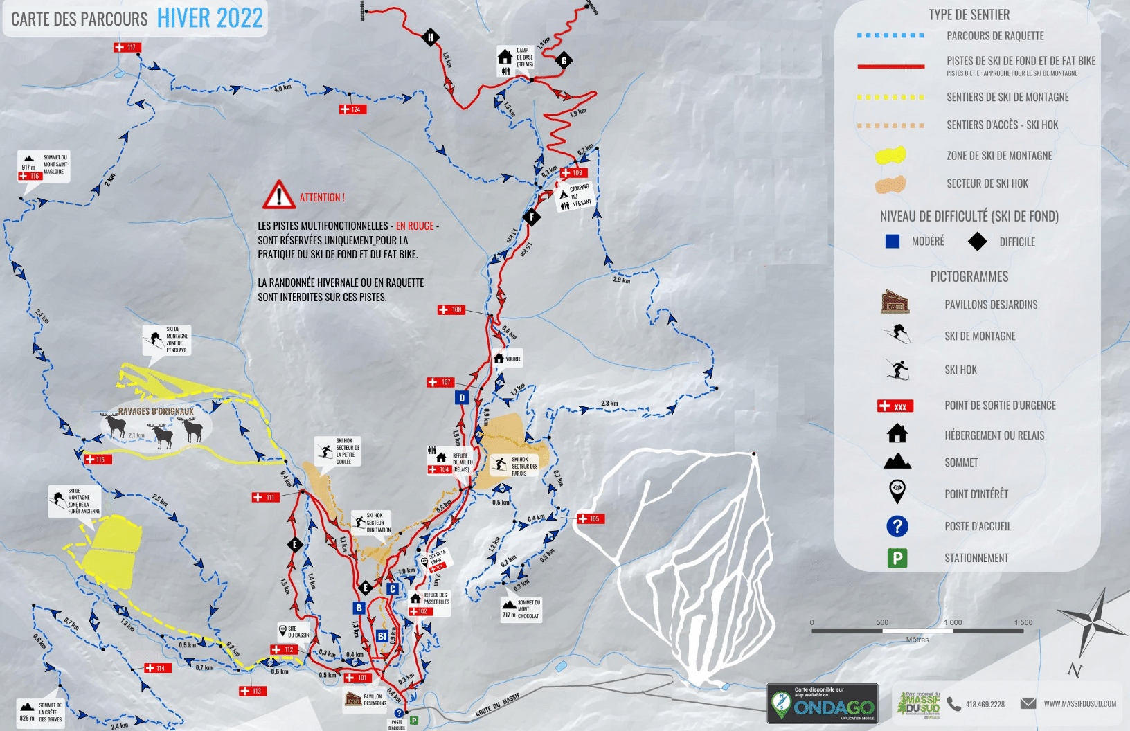
Trail map |
See trail map |
You can also use our geolocated map on ONDAGO.

Choose your itinerary
C - Rating: moderate – Length: 4.1 km – Average time: 45 min (adults); 1 hour (children) – Last departure: 2:30 pm
A short loop on each side of the Milieu river with a cabin midway, for a rest stop.
B-E-C - Rating: moderate – Length: 5.6 km – Average time: 1 hour (adults); 1.5 hour (children) – Last departure: 2:30 pm
You guys like going down? This route invites you to take advantage of two of the most exhilarating descents of the network, one in the heart of a maple grove and the other from the refuge du Milieu. Difficult to resist!
E-C - Rating: difficult – Length: 6.6 km – Average time: 1 hour (adults); 1.5 hour (children) – Last departure: 2:30 pm
With its hilly terrain and short turns, this trail is made for more technical skiers. A beautiful loop set amidst a forest of yellow birch, sugar maple and fir.
C-D-C - Rating: moderate – Length: 7.1 km – Average time: 1 hour (adult); 1.5 hour (children) – Last departure: 2:30 pm
A complete loop of the Milieu valley, from one side to the other.
E-C-D-C - Rating: difficult – Length: 9.6 km – Average time: 1.5 hour (adult); 2 hours (children) – Last departure: 2 pm
Why not enjoy it a little longer and discover the two main valleys of the park?
C-D-F-D-C - Rating: moderate – Length: 13.9 km – Average time: 2.5 to 3.5 hours – Last departure: 12:30
Climb all the way to the Camp de base and take in the view of the Milieu valley and the surrounding mountains. Enjoy your lunch and a hot drink inside, as the Camp de base is open to skiers during the day, before gliding your way down to the visitor center.
C-D-F-G-H-F-D-C - Rating: difficult – Length: 18.6 km – Average time: 3 to 4 hours – Last departure: noon
A little higher, a little further… You are not afraid of the ascent or the descent? This is for you! Climb over 500 meters and then enjoy an exhilarating descent. GPS users can download the GPX file of this itinerary by clicking here.
